THE LOCATION OF ROBERT WALKER'S
HOUSE:
I've
exchanged some recent notes with Randy Walker, who has done some careful
research on the Walkers who lived in Surry (now Forsyth) county, North
Carolina. One question I asked was if he could pin down the rough location of
Robert Walker's original house, and that started a discussion. Randy had lived
in the general area, and we exchanged ideas.
The
following is based largely on the appearance of Robert Walker's name in the
1771 survey of what was to be the southern boundary of the newly formed Surry
County. (Within a couple of years the final boundary was located about 6 miles
further south, in order to incorporate all the Moravian (Wachovia)
Tract.)
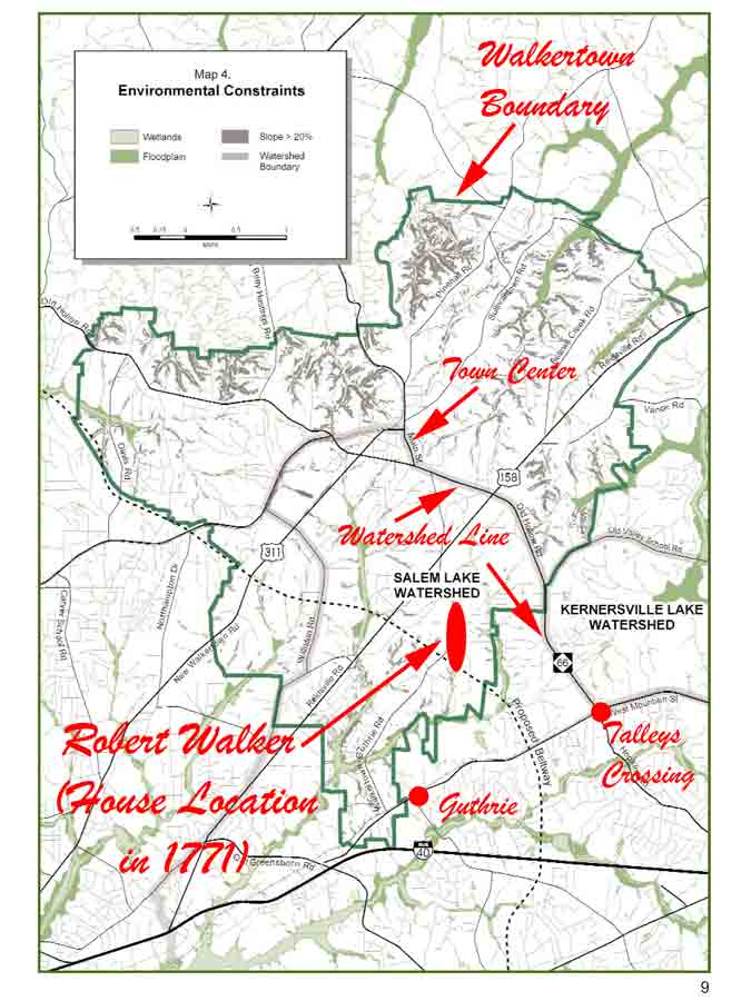
I
found a planning map on the Walkertown web page, which shows the Walkertown
Watershed areas, and which allows us to pin it down with fair confidence.
Click on this link to see the relevant map and annotations (and maybe print it
out for reference).
Next,
consider the words from the 1771 Survey, as it passes Robert’s house: ". . . running west crossing a branch
of Dan River East of Robert Walkers Esquire, thence East of his house about
one-quarter of a mile, crossing the easternmost Branch of Muddy Creek . . .”
Now,
you need to realize that the Dan River is to the north, and streams leading
into it are flowing north. And Muddy Creek is to the south, and streams leading
into it are flowing south. So, in this Survey description, they are crossing a
north-flowing stream, then crossing the watershed boundary, then crossing a
south-flowing stream, and that latter stream is one-quarter mile east of
Robert’s house.
So
where can we see these on the Walkertown Watershed map? The first stream is likely
the one that today feeds modern Kernersville Lake, and is in the Kernersville
Lake Watershed. In 1771 the Lake was not there, so it just flowed on to the Dan
River.
Then
the map shows the Watershed Boundary, and on today’s map this boundary follows
Old Hollow Road.
Now
we are in the Salem Lake Watershed. All the streams in this area flow south,
and I believe that in 1771 they were all loosely called “Muddy Creek”.
Eventually they entered the Yadkin River. But now there is a dam, so now they
flow into Salem Lake.
So,
where was Robert’s house? Our west-bound 1771 Surveyors needed to pass an area
far enough north to encounter a stream flowing north into today’s Kernersville
Lake, cross the watershed boundary, then cross a stream far enough south to
flow into today’s Salem Lake, then walk one-quarter mile farther to reach
Robert’s house. And that would be roughly the red oval area on the annotated
watershed map.
So,
how would we find it today? Get in your car, and ask Google Maps to get you to
the unincorporated community of Guthrie, NC. Then take the Walkertown-Guthrie
road north for maybe 1.5 miles. From there, within the next mile or so, you
should pass within a few hundred yards of Robert’s old house site. Maybe pull
into the parking lot for the 6000-member Gospel Light Baptist Church and look
around?
A
final supporting item: The above survey called the first stream a “branch of
Dan River”. However it is also clearly a branch of “Belews Creek” (Belews Creek
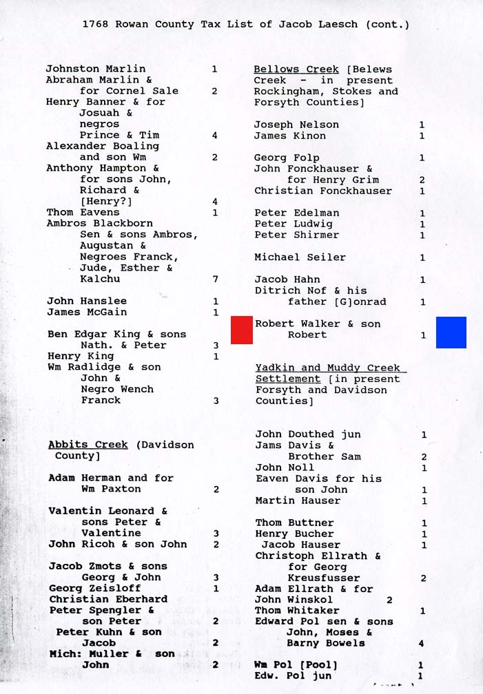
is the path it takes to the Dan River). The Rowan Co Tax list shows Robert
Walker on 1768 tax list of Jacob Laesch. This list is for Bellows Creek (aka
Belews Creek). So Robert was in this general area no later than 1768. This 1768
tax list probably refers to the same area we have been looking at, given that
the area overlaps the “Bellows Creek” and “Muddy Creek” drainage areas.
AN OLDER ANALYSIS:
The
following is an older analysis, which attempts to trace the path of the survey
across the entirety of modern Forsyth County. It goes into a more detailed
discussion, and yields a broadly similar result. However it suggests an area
closer to Guthrie. (In our original debate, Randy said “But I think Guthrie is
too far South!” I now agree with him, and like the above better.)
I've
annotated a Topographical Map of the Northern
Forsyth County area, marking it up to try to show areas relative to the
words in this survey. Click on the above to see the map. I recommend you print
this text you are now reading, and then follow along while scrolling about on
the map:
Here
are the words of the relevant part of the 1771 Survey, with my comments
interspersed in italics:
"Beginning
again for the dividing line between Rowan and Surry"
This
dividing line was to be positioned at 42 miles north of the Granville Line,
which marks the southern border of Randolph, Davidson and Rowan Counties. I
have marked on the right side the Topo map the approximate "42 mile"
starting point.
(Actually
I had a little trouble with the location of the Granville Line: One source said
it was supposed to be at 35°34'N, but when I look at the location of the
southern border of the referenced counties, I find that border at 35°30.4'N. I
have assumed that the quoted "35°34'N" reference is either a typo, or
they used a different datum, or the 18th century surveyors were not
that precise in their position calculation. I have assumed that the Surry
Survey was relative to the actual position of the southern border of what was
then Rowan County. If I were to use the"35°34'N" as a starting point,
then the mark would be almost 4 miles further north, and more in line with the
town center of Walkertown.)
"at aforesaid Post Oak ('standing
in a hollow at a small distance from the Reedy Fork of Haw River and on the N.W.
side),"
I've
marked in green three sub branches of Reedy Fork, Haw River, on the right side
of the Topo map. Reedy Fork is indeed all quite close to my "42 mile"
mark. (I take this as additional evidence that my starting point for the
Granville Line at "35°30.4'N" was correct.)
"running
west crossing a branch of Dan River East of Robert Walkers Esquire,"
Tributaries
of both East Belews Creek and West Belews Creek come very close to this area,
and Belews Creek definitely drains into the Dan River. I see that one branch of
East Belews Creek comes down into the northern suburbs of Kernersville, so this
is a very likely candidate for the "branch of Dan River" that they
crossed.
"thence
East of his house about one-quarter of a mile, crossing the easternmost Branch
of Muddy Creek,"
There
is no "Muddy Creek" on this part of the Topo map. However there is a
"Kerners Mill Creek" in about the right location. Since the
"Joseph Kerner" who founded Kernersville didn't buy land in this area
until 1871, it's quite certain that the creek it had a different name in 1771.
This creek is very near the present community of Guthrie, NC.
Randy
Walker advises that what was once called the Middle Fork of Muddy Creek later
became known as Salem Creek, and this "Kerners Mill Creek" is, on the
topographical map, clearly the "easternmost branch" of Salem Creek.
It fits perfectly!
(There
is also a "South Fork" of Muddy Creek, which is off this map to the
south. And there is a "West
Fork", which is still called "Muddy Creek" on this modern
topographical map – we'll discuss this shortly. Basically, all the
south-flowing streams in the vicinity of the modern city of Winston-Salem drain
into Muddy Creek, and it seems that in 1771 they tended to call all the
branches "Muddy Creek".)
"thence
through the Moravian Tract,"
I
haven't found the exact GPS coordinates of the eastern side of the Moravian
Tract, but from a sketch I found I believe it was about six miles west of the
Guilford County Line. I also believe the community of Walkertown was just
outside of it. Therefore I have drawn a vertical line through the Topo map at
the rough location.
"crossing
the fork of the road that from Bethabara (to) Salsbury and about one and half
mile from Bethabara,"
I've
drawn a red star at the location of Bethabara, and a red vertical line showing
1.5 miles.
"then
crossing the Moravian Mill Creek at 2 and half mile from said roads,"
I've
shown the Mill Creek in green, and drawn a 2.5 mile horizontal red line. The
crossing point looks just about right.
"crossing Muddy Creek at about six miles from
said roads"
I've
shown in blue the stream that the modern topo map calls "Muddy
Creek". The above Mill Creek
drains into it. (Note that this passes near the town of "Muddy Creek"
at the VERY BOTTOM of the map – this is within a mile or so of where the
three branches of the old "Muddy Creek" come together before draining
into the Yadkin River.
However
on the modern map this blue "Muddy Creek" is much too close to the
green "Mill Creek" to be "six miles from said roads". I think that when they crossed this
modern version, they were calling it "Mill Creek".
I
believe they tended to call ALL the branches in the area "Muddy
Creek", since they all eventually came together. See the above discussion
of another "Muddy Creek" they crossed before they even entered the
Moravian Tract.
I've
drawn a six-mile horizontal orange line. There are several creeks along the
left part of this line, and any one of them could have been described as
"crossing Muddy Creek at about six miles from said roads".
"at
2 miles to Christopher Smiths Plantation, thence through George Robinsons
Plantation and his yard to a mulberry house in Rowan,"
Afraid
I can't find these landmarks on today's map! Maybe they repainted the house?
"thence
crossing the Shallowford Road at two oaks, the one marked Rowan the other
Surry,"
I
did mark today's "Shallowford Road" on the map in yellow. However I'm
convinced this is a more modern version of the road that was going to Salem,
and in 1771 they are talking about an older road that went to Bethabara. So I
don't know where they crossed.
"thence
about 5 mile to the Yadkin"
It's
a little unclear, but they've gone AT LEAST 11 miles since they left the road
between Bethabara and Salsbury. I've drawn an "11 mile long blue
line", and the only way to fit it in is if they approached the Yadkin by
passing BELOW the area where the Yadkin is flowing east-west.
"through
Benjamin Stewarts old field on the N. degrees bank of the Yadkin,"
I
suspect this "N. degrees bank" refers to the area where the Yadkin is
flowing roughly north-south. Therefore they passed just below the mapped bend
in the river.
"crossing
Yadkin by Joseph Gentrys land about a quarter of a mile above his house in
Rowan…"
THE SURRY COURT MINUTES:
There
is another small piece of evidence in the court minutes for 16 February 1787.
It reads:
"Ordered
John WRIGHT overseer, road from Salem to Moravian line near Robert WALKERS old
habitation. Ordered John CUMMINS overseer, road from Moravian line near Robert
WALKERS old habitation to Guilford County line."
This
tells me that Robert's house was indeed very near the Moravian line. And such a
road would likely be headed to the Greensboro area in Guilford County, and
would thus be roughly due west of Salem. I believe "Walkertown" is a
bit too far to the north, and that this road was probably passing closer to the
present community of Guthrie.
CONCLUSION:
Using
the various marks, there is an uncertainty band across the county that is
perhaps a mile wide. However the modern community of Guthrie is right in the
middle of this band, just to the right of the Wachovia line.
EARLY TAX LIST RECORDS:
Robert
is found on the Rowan County Tax List for 1768.
The
Rowan Co Tax list shows Robert Walker on 1768 tax list of Jacob Laesch. This
list is for Bellows Creek (aka
Belews Creek), The listing is "Robert Walker & son Robert 1
poll". They have no slaves. (The one poll tax is probably for Robert Jr.,
and Robert Sr. is possibly not required to pay the poll tax because he is older
than age 50 at that time.)
I
don't know the boundaries of the Belews Creek tax list in 1768, but my
"theory" about Guthrie may be a little weak here. Guthrie is in the
"Muddy Creek" drainage area. While Belews Creek drainage does extend
this far south, it is more in the vicinity of Kernersville. (So maybe the
location is a bit farther north than Guthrie? And the 1768 Tax List was more an
administrative convenience than a precise watershed location?)